Rapid Transit for Toronto’s Waterfront

Toronto’s true development potential is on the waterfront.

The Port Lands is the largest brownfield redevelopment opportunity in North America. It covers 880 acres of prime waterfront land, located less than five kilometers from downtown Toronto. The economic potential of this city-sized parcel of land offers a truly once-in-a-generation opportunity. Current plans call for a new, mixed-use city district with up to 25,000 new residents and commercial space for up to 30,000 new jobs

Two projects are required to unlock the Port Lands’ full economic potential: flood protection and a transit link with the existing downtown network. With cooperation from all three levels of government, the $1.25-billion Port Lands Flood Protection project is already underway. Transit is the next step forward.
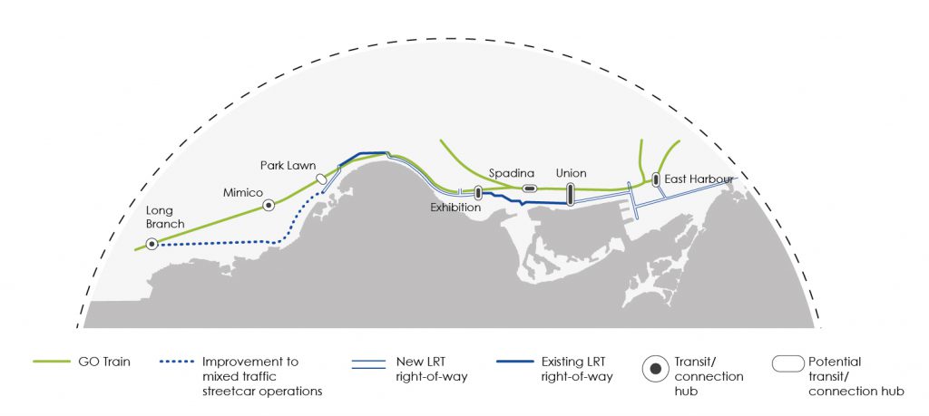
The proposed Waterfront LRT requires similar collaboration, most critically among the City of Toronto, the TTC, Metrolinx and Waterfront Toronto. The project would connect Woodbine Avenue in the east with Long Branch in the west, creating a new 22-kilometre long transit corridor across Toronto’s beautiful waterfront. Taken together, this represents a series of short and long-term projects — a “waterfront transit network”. The eastern portion of the Waterfront LRT is especially urgent because it will unlock the economic potential of the Port Lands. A smaller section of the larger proposal, the Waterfront East LRT alone is expected to spur 25,000 new housing units and 19 million new square feet of office space.

The full Waterfront LRT will also connect under-served, highdensity nodes along the western waterfront, like Humber Bay Shores; it will improve connectivity to some of the GTA’s major tourist destinations, like Exhibition Place, BMO Field and a re-imagined Ontario Place. The line will also relieve pressure from the overcrowded 504 King Streetcar allowing faster, dependable and more comfortable travel.

Without provincial support and funding, the Waterfront LRT will remain on the drawing board. The Province should accelerate the planning and delivery of this important new transit corridor.

Cost Estimates

  • $2 billion to $2.5 billion for the east and west portion of the project

Rough Timelines

  • Early design

Current Status

  • Project is likely to be delivered in stages, with some stages potentially being completed within five years. Full build-out is expected over a 15 to 20-year period.

Project Details

Approximately 20 kilometres of new LRT track on west corridor along Toronto’s waterfront from Long-Branch to Union Station
Approximately 7 kilometres of new LRT track from Union Station to Woodbine Beach

Economic Benefits

$3.8 billion in tax revenue to the Province just as a result of the eastern portion
Accelerates and supports delivery of up to 25,000 new housing units
Provides an estimated 14% reduction in travel time just from the eastern portion of the LRT

More Projects

Ontario’s Clean Energy Potential

Exploring clean energy solutions including renewable natural gas, charging infrastructure for electric vehicles, and hydrogen that will help strengthen Ontario’s role as an innovative leader.

About this Project

Broadband to Address the Urban-Rural Digital Divide

Continue the Province’s unwavering commitment to broadband infrastructure and seek further commitments from the Universal Broadband Fund and the Canada Infrastructure Bank.

About this Project

A New Freeway and 21st Century Border Infrastructure for the Niagara Peninsula

Creating a new freeway as a supplemental transportation corridor to the Queen Elizabeth Way and twinning the Peace Bridge to alleviate the border bottleneck of goods and people.

About this Project

A Strategic Transportation Link to Ontario’s Ring of Fire

Construct a north-south roadway to the Ring of Fire to untap Canada’s largest known source of mineral wealth.

About this Project

Frequent and Reliable Rail Service between Toronto, Ottawa and Montreal

Creating new and dedicated tracks for passenger trains to support easy and efficient travel between the thriving economies.

About this Project

The Ontario Line Subway

A 16-kilometre long Ontario Line to create new north-south and east-west routes to and from the City’s Central Business District.

About this Project

An Eastern GTA Transit Hub

The number of transit projects in the region that are currently in the planning stages should be tied together with other modes of existing transit and transportation using a new multimodal Eastern GTA Transit Hub.

About this Project

Extending the Yonge Subway into York Region

This project will enhance north-south connectivity in the northern GTA, linking Union Station in downtown Toronto with Richmond Hill Centre in York Region.

About this Project